File:Gor-map-simplified.png

Summary
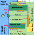
An intentionally ultra-simplified and un-detailed map of the known areas of the planet Gor (the setting of John Norman's series of science fiction books), based on the verbal descriptions of Gorean geography given in the books.
There is no attempt to use geographically realistic shapes (e.g. indented coastlines, meandering rivers, etc.). Instead, the basic continental coastline, rivers which flow directly into the sea, mountain ranges, and major vegetation-climate zones (i.e. the northern forests, equatorial jungles, arctic zone, and Tahari desert) are all depicted with only very simple geometric shapes (straight lines, circular arcs, etc.)
Only a small number of cities and islands are shown on the map -- just those few cities and islands which are of major civilizational importance in Gorean history (Ar, Cos, Turia), and also some port cities located where rivers meet the ocean (Lydius, Port Kar, Schendi).
The area of the main northern-hemisphere city-states (or the "northern civilized cities of known Gor", as it's referred to in Assassins of Gor, book 5 of the series) is where the main default form of Gorean culture is typically practiced (as opposed to somewhat divergent or "barbarian" cultures in outlying regions). This is labeled on the map as "Civilized Gor" (i.e. generally the area south of the northern forests, west of the Voltai mountains, and north of the equatorial rainforests, excluding the swamps of the Vosk river delta, but including the islands of Cos and Tyros).
There are doubtless some remaining inaccuracies with respect to Norman's original intentions, even taking into account the map's extreme simplification. The Tahari and Barrens are shown as filling up the entire area to the east of the Voltai and Thentis mountains, but they may be confined to more limited zones. An area of complete geographic ignorance at the northeast corner of the map has a northward-pointing arrow and the symbol of the three moons of the planet Gor superimposed over it...
Licensing
This image is declared to be public domain (see File:Gor-map-simplified.svg on Wikimedia Commons for a resizable vector version, and further description and source information).
| This image has been (or is hereby) released into the public domain by its creator, AnonMoos. This applies worldwide. In case this is not legally possible, the creator grants anyone the right to use this work for any purpose, without any conditions, unless such conditions are required by law. Subject to disclaimers. |
File history
Click on a date/time to view the file as it appeared at that time.
| Date/Time | Thumbnail | Dimensions | User | Comment | |
|---|---|---|---|---|---|
| current | 16:44, 6 February 2009 |  | 580 × 600 (28 KB) | AnonMoos (Talk | contribs) | An intentionally ultra-simplified and un-detailed map of the known areas of the planet Gor (the setting of John Norman's series of science fiction books), based on the verbal descriptions of Gorean geography given in the books. There is no attempt to |
- Edit this file using an external application (See the setup instructions for more information)
File usage
The following 2 pages link to this file:
